"Click" here to go to RSeasons.com Home Page
 
RFamilyData.com Navigation Buttons    


Pictorial History Of Monroe, Wisconsin
            Green County Historical Society, 2006
      

Page 2      


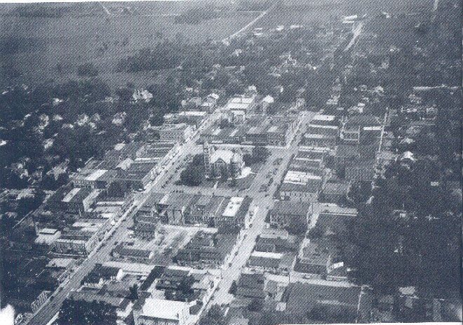
1929.  It is very easy to find the Green County Courthouse in the center of this aerial photograph that overlooks the north part of the city. At the time this picture was taken, the population of Monroe was about 5,000. It is fun to pick out Churchill (North) School! the Ludlow Hotel, the Universalist Church, the Fitzgibbons building, the fire station in Spring Square, the National Guard Armory, City Hotel, and the old Turner Hall. One can also see the land that was named Twining Park 30 years later.

            The road that leaves Monroe on the northwest (now) known as 14th Avenue which then turns into 2nd Street) was known as the Argyle Road. Willis Ludlow lived in the house, which was later White Haven Nursing and Convalescent Home, just west of that bend. Following 17th Avenue north from the east side of the square leads one to the Illinois Central railroad tracks on the north edge of the city. The street that leaves Monroe on the northeast comer was previously known as Madison Road now 18th Avenue (in the upper-right comer of the picture).

            As you read the rest of this book you may want to refer to this photo. It may help you to determine the location of buildings and businesses.


This symbol indicates:
not complete, or more information needed . . .
please E-mail
your information, corrections, documents, photos,
inquiries, or any other needs to:

Webmaster@RFamilyData.info


Return to Top of Page


Revised: 8-13-09


<---- Click Logos ---->
for Rewarded
Support


RFamilyData.info Website
family genealogy

© Copyright 2003-2010 by CONCEPTUAL Applications

Website Design by:   CONCEPTUAL  Applications
a division of: WebComm21